
Image from weather.gov
Fox weather writes:
March is typically recognized as the battle between winter and spring, and the arrival of a new workweek has left nearly 170 million people shivering in colder-than-average temperatures Monday, with the risk of winter weather, including dangerous snow squalls and lake-effect snow, from the Great Lakes to the interior Northeast and the northern and central Appalachians.
On Monday morning March 18th, The National Weather Service (NWS) issued this statement in a short range public discussion for the nation:
The new workweek will start off by featuring a weather pattern consisting of high pressure stretching southward from the northern Plains to the Gulf Coast. As a result, continuous cold northwest flow will create lake effect snow chances throughout the Great Lakes today before the next clipper system swings over the region and into northern New England by early Wednesday. Accumulating snow is expected across the typical snow-belts downwind of lakes Erie and Ontario, as well as into northern Michigan, where Winter Weather Advisories have been issued. Snow showers could expand into the Interior Northeast and northern New England on Wednesday as the aforementioned clipper system swings eastward, with the potential for accumulating snowfall particularly in the elevated terrain.
This push of cold air underneath and just east of the high pressure settling over the Deep South on Tuesday will allow for subfreezing temperatures to extend as far south as the Lower Mississippi Valley and Southeast. Frost/freeze conditions could damage and/or kill any unprotected sensitive vegetation, prompting Freeze Watches and Warnings to extend from Arkansas to the Carolinas. This cold isn’t anticipated to be long-lived as temperatures gradually warm by midweek.
As seen in the map at the top of this post, much of the southern United States is affected.
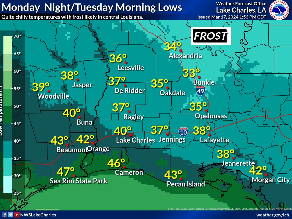
The southernmost state affected by the freeze warning is Louisiana, which normally has mild temperatures this time of year. The NWS at Lake Charles LA issued this statement on Monday:
…FREEZE WATCH HAS BEEN UPGRADED TO A FREEZE WARNING…
…FREEZE WARNING IN EFFECT FROM MIDNIGHT TONIGHT TO 9 AM CDT TUESDAY…
* WHAT…Sub-freezing temperatures as low as 33 expected.
* WHERE…Avoyelles and Rapides Parishes.
* WHEN…From midnight tonight to 9 AM CDT Tuesday.
* IMPACTS…Frost and freeze conditions could kill crops, other sensitive vegetation and possibly damage unprotected outdoor plumbing.
The NWS in Lake Charles also provided a low temperature forecast graphic on their Facebook page: