
The U.S. National Weather Service issued Winter Storm Warnings for western and central Montana in mid-February for extremely cold temperatures and heavy snow.
KRTV 3 described the snow as “impactful.” Temperatures were well below normal for the dates February 14 through 16. The average highs for those dates are 37℉ (14) and 38℉ (15 and 16) degrees, with the average low hovering at just 16 for all three dates. In 2024, the low temperatures for those dates were 11℉, 3℉, and -12℉, respectively, and the highs for those dates only reached, 20℉, 13℉, and 17℉. High winds resulted in windchills dipping to -25℉ below zero, prompting the NWS to issue Wind Chill Warnings.
More than 7 inches of snow fell in Helena, Montana on February 15. Heavy precipitation in the form of snow has been the norm for this region of Montana during February 2024, thus far. The NWS wrote on its Facebook page that February 2024 is setting records for precipitation (moisture content in the form of snow, in this case):
Over the first 14 days of February (1st thru the 14th) the Great Falls Area has measured 1.64″, which is the wettest (#1) first 14 days of February on record (previous record was 1.48″ set in 1923).
Over the first 14 days of February (1st thru the 14th) the Helena Area has measured 1.29″, which ranks second (#2) wettest for the first 14 days of February on record (record is 1.59″ set in 1895).
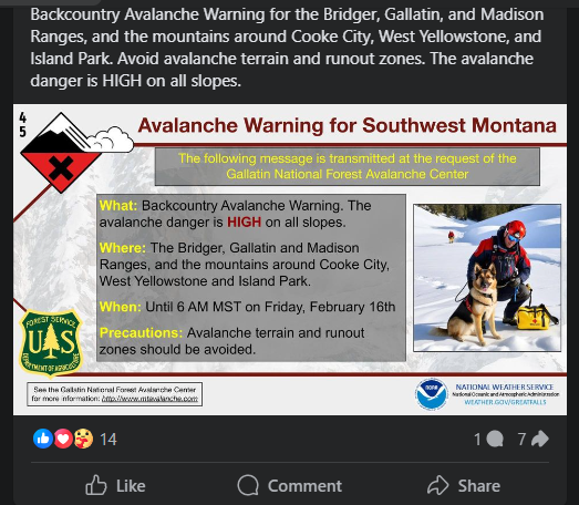
The snow accumulation and high winds resulted in the NWS issuing Avalanche Warnings for the mountains in the southwestern part of the state.