
A Nor’easter is bringing strong winds and heavy snowfall from the central Appalachians through southern New England which could damage trees, power lines, and disrupt travel. As seen in the satellite image above, the storm is just off the coast, and pushing moisture laden ocean air into contact with cold air inland resulting in a snow making machine.
Multiple Winter Storm Warnings have been issued by local National Weather Service (NWS) offices. With winds as high as 60 miles per hour, blizzard conditions are expected.
Philadelphia:
…WINTER STORM WARNING REMAINS IN EFFECT UNTIL 3 PM EST THIS AFTERNOON…
* WHAT…Heavy snow. Total snow accumulations of 5 to 9 inches. Winds gusting as high as 35 mph.
* WHERE…Portions of central, northern, and northwest New Jersey and east central and southeast Pennsylvania.
New York City:
…WINTER STORM WARNING REMAINS IN EFFECT UNTIL 6 PM EST THIS EVENING…
* WHAT…Heavy snow. Total snow accumulations of 6 to 8 inches. Locally higher amounts possible in heavier bands.
* WHERE…Portions of southern Connecticut, northeast New Jersey and southeast New York.
* WHEN…Until 6 PM EST this evening.
* IMPACTS…Travel could be very difficult. The hazardous conditions could impact the morning or evening commute. The heavy snow load on trees could bring down scattered branches with power outages possible.
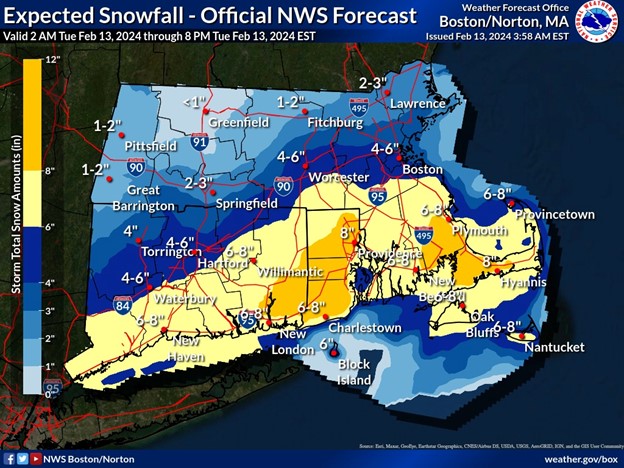
Boston:
…WINTER STORM WARNING NOW IN EFFECT UNTIL 7 PM EST THIS EVENING…
* WHAT…Heavy snow. Storm total snow accumulations of 4 to 9 inches. Winds gusting as high as 60 mph.
* WHERE…In Massachusetts, Barnstable, Dukes and Nantucket Counties. In Rhode Island, Block Island.
* WHEN…Until 7 PM EST this evening.
* IMPACTS…Travel could be very difficult. The hazardous conditions could impact the morning or evening commute. Strong winds could cause tree damage.
NWS Boston reports in a Special Weather Statement:
Snowfall rates of 1-2″ per hour are occurring across the Lower Hudson Valley and southwestern CT this morning. These bands of heavier snowfall will shift south over the next few hours through about noon, leading to quickly covered roads and hazardous driving conditions. Drivers are urged to use extra caution.
A map of expected snowfall was also provided: