


The nation’s capital is being pummeled by a 1-2 punch of bitter cold followed by yet another snowstorm after two to six inches blanketed the area last Monday and Tuesday. Wind chills dropped into the single digits and even below 0 in some places in the Beltway area Tuesday night.
The National Weather Service for Washington D.C. – Baltimore MD (NWS) made this graphic below with the caption:
Cold temps & bitter wind chills continue tonight with high pressure centered to the south. Lows will fall into the teens with wind chills back in the single digits.

The NWS also noted the next approaching storm on Twitter:
Snow arrives late tonight-Fri. AM. Winter Weather Advisories have been issued for 1-3″ of snow across most of the region. Locally higher amounts up to 4″ are possible north of I-70. The steadiest snow arrives between 6am-12pm Friday. Highest snow totals over the mountains.
They added:
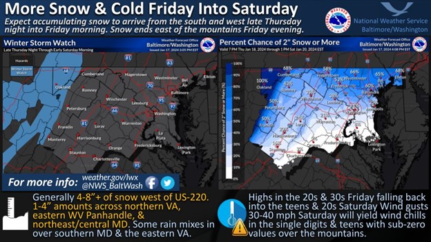
Winter Storm Watches have been issued west of the Allegheny Front where 4-8″+ of snow is expected through Saturday. Elsewhere 1-4″ of snow is expected with the bulk of the accumulation Friday morning into Friday afternoon.