
AccuWeather writes:
A winter storm watch has been issued for parts of western New York ahead of a long-duration lake-effect snow event that could produce potentially record-setting amounts of 3 to 6 feet.
…
AccuWeather meteorologists say the fiercest lake-effect snow event yet this season — and potentially in years — will ramp up downwind of the Great Lakes late this week and bury some locations with feet of snow, grind travel to a halt, and potentially stamp new marks in the weather history books.
Forecasters warn that travel could be difficult to nearly impossible amid the heaviest snow bands, including along sections of Interstate 90 in the Buffalo, New York, area and I-81 north of Syracuse. Snowfall exceeding the rate of 2-4 inches per hour is anticipated in some areas, with thundersnow possible in the most intense bands.
However, the Buffalo National Weather Service (NWS) office suggests lesser amounts through Wednesday, as seen in the graphic above, saying:
“Before the lake effect snow starts this week, we will have a light synoptic event late this afternoon through tomorrow. A few inches of wet snow is likely, with around 4 inches possible on the Tug Hill. Get those snow brushes out and be prepared before traveling.”
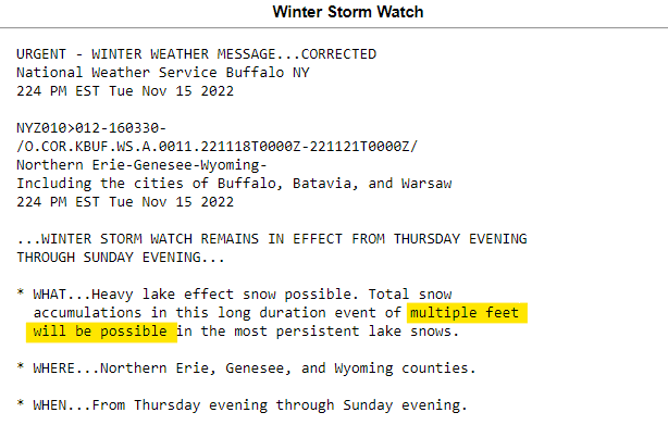
The really big snowfall amounts will come Thursday through Sunday, according to the NWS Winter Storm Watch: