Image: Weatherzone.com.au
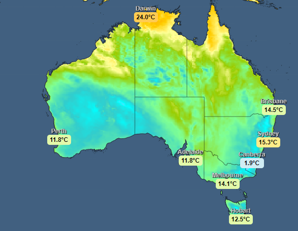
Queensland Australia is experiencing a cold blast, with temperatures across the south-east part of the continent about 4-8°C below the July average over the past few days. The Guardian Newspaper reports on the July cold snap:
Queensland shivered through a record-breaking cold snap on Monday, with overnight temperatures at more than 80 Bureau of Meteorology (BoM) sites lower than in Melbourne.
Brisbane’s minimum temperature of 6.3°C – recorded at Brisbane airport – was more than three degrees lower than the Victorian capital’s minimum of 9.9°C, the weather bureau said.
Tropical north Queensland temperatures plummeted, with Cairns recording just 11.4°C overnight and Townsville dropping to 8.6C.
The temperatures were below normal, according to an interview with the Bureau of Meteorology:
According to BoM senior meteorologist Harry Clark, many south-east Queensland thermometers registered their lowest temperature of the year.
“Generally, we’ve been about four to eight degrees below the July temperature averages in terms of minimum temperature across south-eastern Queensland the last few days,” he said.
Temperatures in Australia’s mountainous regions were even lower with the extended cold spell being accompanied by a large dump of snow, there.
The Guardian reported that on June 19 and 20 a massive amount of snow fell, boosting the fortunes of Australia’s ski resorts.
“Christmas in July has finally arrived for ski resorts this weekend as the first widespread snowfall of the season blankets parts of Australia’s south-east, bringing more than 50cm falls in popular tourist destinations,” said the Guardian. “David Clark, destination marketing manager for Mt. Buller and Mt. Stirling ski lifts, said the snow ‘just keeps coming.’”
In just 24 hours, on July 20, Mount Hotham saw 31 cm of snow fall and at Thredbo ski resort, more than 27 cm of fresh snow fell, bringing its total snowfall for the week to 43 cm.
Snow-forecast.com reported that the recent snow was the “biggest snow day of the year to date … [with] [r]esorts report[ing] up to 60cm (2 feet) of snowfall so far and coming on top of a smaller 20-30cm (8-12″) fall at the start of last week, it takes 7-day totals to nearly the meter mark.”
Falls Creek, in the Victorian Alps, joined Mount Hotham in receiving plentiful snow, with amounts topping 53 cm over the weekend. When added to the snow that fell earlier in the week, Falls Creek saw more than 80 cm snowfall for the week.
If the low-pressure system lingers as expected, as much as 50 cm of additional snow is forecast to fall, by the Australian Bureau of Meteorology, over the coming week.


